

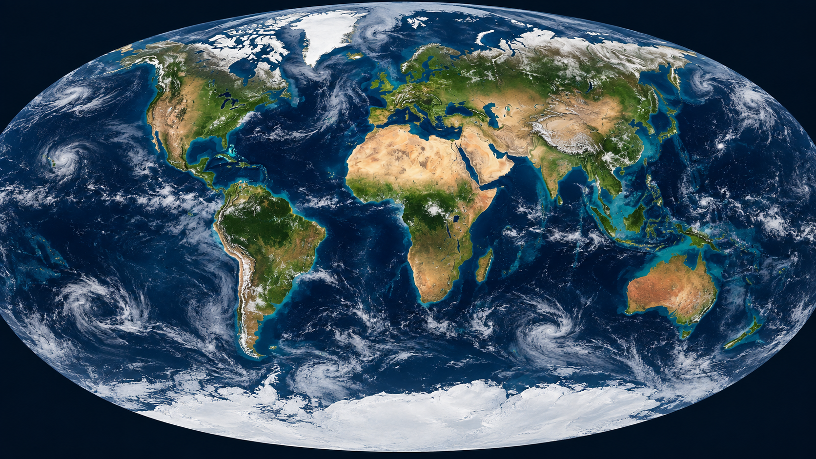
Equal Earth – Africa Was Never Small
On Friday, the UN General Assembly voted to show Africa at its true scale. While this was a major symbolic victory for Africa, the implications go far beyond the maps.
The United Nations General Assembly voted overwhelmingly to endorse the Equal Earth map projection. 164 countries supported the measure. Only the United States opposed it. The resolution is not binding or legally enforceable, and does not ban or abolish the Mercator projection. What it does is encourage governments, schools, media and technology companies to adopt maps that show the actual relative size of the world’s continents. And it is now backed by a near-unanimous world community.
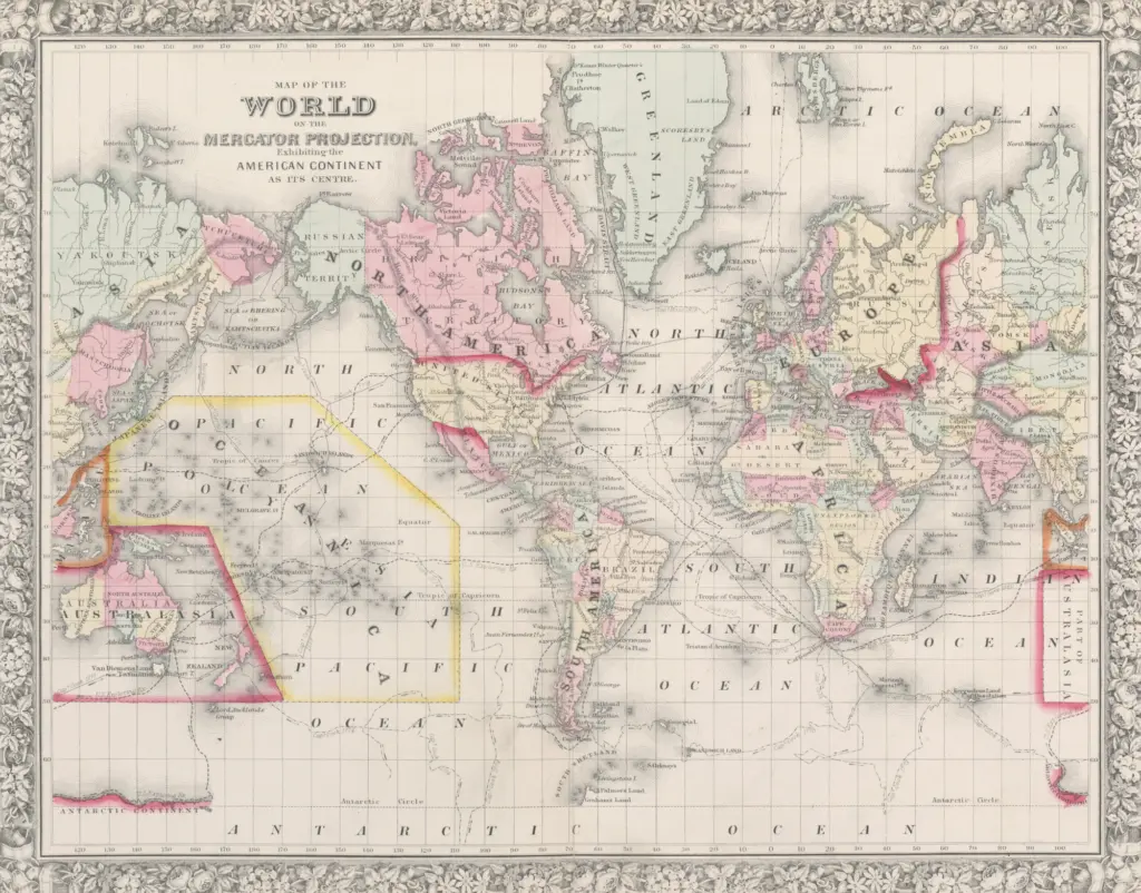
It’s easy to dismiss this as a technicality, but maps shape our understanding of the world. For more than four centuries, most world maps have made Africa look much smaller than it is, with Greenland as the most infamous example. The Mercator projection typically shows Greenland and Africa roughly similar in size, while in reality, Africa is about 14 times larger.
The Equal Earth projection changes the visual hierarchy, making Africa impossible to overlook. Africa covers roughly 20% of the world’s land area and is home to around 19% of its population, close to 1.6 billion people. Yet the continent accounts for only around 3% of global nominal GDP. The last figure is obviously nothing to celebrate. It does, however, show the magnitude of the untapped growth potential.
Mercator was solving a different problem
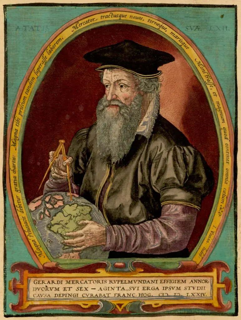
Some may be tempted to demonize Gerardus Mercator, but that would be unfair. He was a brilliant 16th-century Flemish cartographer who applied the best of his knowledge to solve a very real problem of his time.
When Mercator published his famous (or now-infamous) projection in 1569, European sailors were crossing oceans, and navigating long coastlines along trade routes that were becoming commercially and strategically vital. His map allowed sailors to plot their course as a straight line. For navigation, that was revolutionary.
It came at the cost of distortion. Flattening the globe onto a sheet of paper inevitably distorts something, and Mercator chose to preserve direction and angles. The further a place lies from the equator, the more its area becomes exaggerated. Northern Europe, Canada and Russia expand, while Greenland becomes almost absurdly oversized. Africa, largely around the equator, does not.
Mercator also drew his map from the perspective of his own time. By the late 16th century, European navigators were increasingly familiar with Africa’s coastlines. Vasco da Gama and subsequent Portuguese explorers had opened the sea route around the Cape, but Europeans still knew little about the vast interior. Much of the African and Arab geographical knowledge built through centuries of trade and diplomacy had yet to reach European cartographers.
To European sailors at the time, Africa was mainly a vast coastline to navigate and trade along, and Mercator’s projection served them well. So well that his 16th-century navigation tool also ended up shaping the default picture of the world for centuries to come.
Equal Earth – Africa, uncompressed
Distance makes the distortion easier to grasp. Cape Town to Casablanca is about 8,000 kilometres, slightly longer than Berlin to Vladivostok. Casablanca is 5,810 kilometres from New York — significantly closer than the 7,940 kilometres to Cape Town.
Dakar to Djibouti is about 6,550 kilometres, longer than the 5,570 between London and New York. Cairo is about 4,400 kilometres from Delhi — much closer than the 7,200 kilometres to Cape Town.
The Equal Earth projection makes the scale of these distances far more obvious on a continent that most of us grew up seeing compressed on wall maps. It also helps explain why talking about “Africa” as one market, one tourism destination or one relatively compact region so often leads to bad analysis.
Translated into road trips, the scale becomes even clearer. Nairobi to Johannesburg is an entirely feasible road trip on tarmac, roughly 3,700–4,000 kilometres depending on the route. It can realistically be done in around a week without turning the journey into an endurance event.
Nairobi to Lagos is a technically manageable 10-day road trip covering about 5,300 kilometres, albeit with very real infrastructure and security challenges, particularly around the Central African Republic. I know people who have driven it. That does not make it an easy journey.
The scale of the opportunity
Africa’s share of global GDP is still disproportionately small compared with its population and landmass. That figure does not tell the whole story, though.
According to the African Development Bank, Africa is home to 12 of the world’s 20 fastest-growing economies in 2025. The continent as a whole grew by 4.2%, comfortably ahead of the global average, and AfDB expects growth to remain above 4% in 2026 and 2027.
Much of that growth is being driven by the private sector, alongside a broader shift away from the old, aid-centered narrative towards trade, investment, infrastructure and commercial partnerships.
Tourism offers a good example. Africa received around 81 million international visitors in 2025, up 8% from 2024, making it the world’s fastest-growing tourism region. Africa is rising fast, but still remains under-visited relative to both its population and what it has to offer.
Africa is no more a single tourism product than Europe or Asia. Its landscapes, cities, cultures and heritage are spread across more than 30 million square kilometres.
The investment is starting to follow the growing demand, albeit from a low base. Africa’s hotel development pipeline is already at record levels. The growth is heavily concentrated in some markets, though, and the ability to turn pipeline projects into operating hotels varies widely between the markets.
Bridging vast distances with better logistics
Africa’s sheer size shows the need for better infrastructure to strengthen trade and connectivity. That is ultimately what many of its most ambitious infrastructure projects are about.
The African Continental Free Trade Area is slowly removing the obstacles created by national borders, gradually building a much larger continental market. Implementation has been slow, but intra-African trade is moving in the right direction. It grew by more than 12% in 2024 to around USD 220 billion. Yet, it still only accounts for about 14% of the continent’s total trade.
African countries still trade disproportionately with markets thousands of kilometres away, and far too little with neighbouring countries. Tariffs are only part of the problem. Border procedures, transport costs, prohibitive regulations and weak infrastructure continue to complicate regional trade unnecessarily.
The same problem is evident in aviation, too. The Single African Air Transport Market, SAATM, was designed to liberalise air services, improve direct connectivity, and strengthen competition. Again, progress has been way too slow. The opportunity is too huge to ignore: To sustain and accelerate Africa’s tourism boom, the continent needs open borders and open skies. This also extends way beyond the tourism industry, to most sectors of the economy.
IATA expects intra-African air travel to grow by around 4.9% annually through 2050, making it the fastest-growing aviation market in the world for the foreseeable future. That growth is starting from a fragmented network where major African cities still are unreasonably difficult and expensive to access from within the continent.
A genuinely open aviation market would create opportunities far beyond the airlines, from airports and cargo to MRO, travel technology, hospitality and tourism. More importantly, it would begin reducing the economic distance between the countries and the regions of the continent.
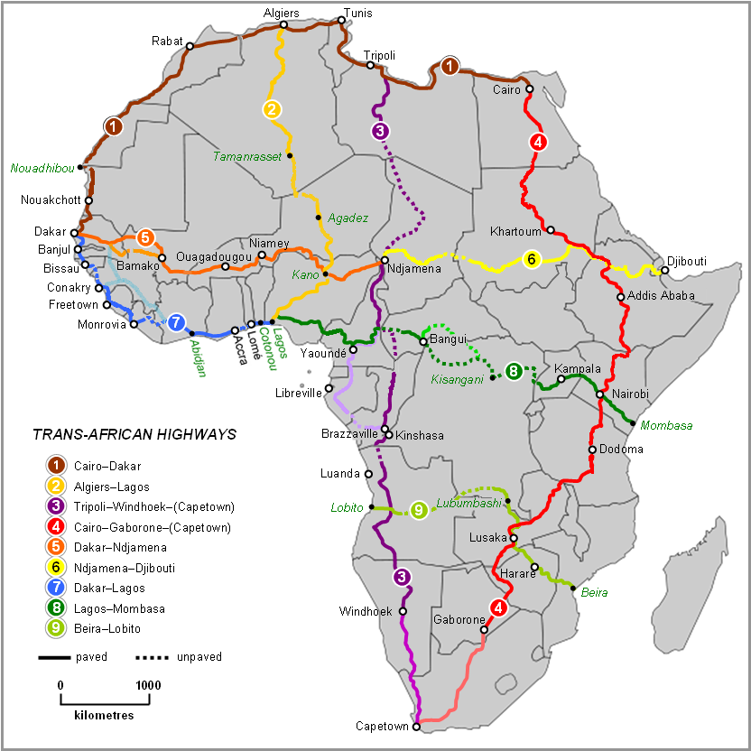
Air transport is only part of the mix, as continental trade also requires reliable ground transport. The Trans-African Highway vision was conceived already in the 1970s, precisely because the continent lacked coherent cross-border transport systems. Colonial infrastructure was mainly built to move goods from the interior towards ports, not to connect African economies for trade within the continent.
The planned USD 15.6 billion Abidjan–Lagos Highway is one of the most important current projects, with a 1,028-kilometre corridor intended to link Abidjan, Accra, Lomé, Cotonou and Lagos. Projects like this could become the physical links on which deeper continental integration depends.
Rail needs the same ambition. The African Union’s Agenda 2063 includes an Integrated High-Speed Train Network intended eventually to connect capitals and major commercial centres across Africa. Much of it remains aspirational, but the continental logic is sound.
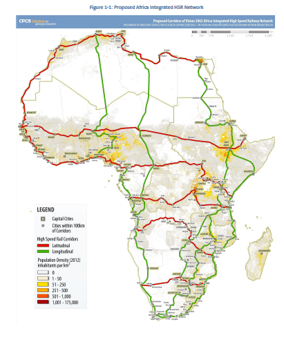
There has long been a Dakar–Djibouti road and rail vision across the Sahel. In East Africa, the Standard Gauge Railway is intended eventually to continue through Uganda towards the Democratic Republic of Congo, with Kisangani appearing in longer-term regional vision.
The ambition should not stop there. If modern rail eventually reaches Kisangani from the Indian Ocean, the next logical step would be to extend it across the Congo Basin to Kinshasa and Brazzaville, then onwards to the Atlantic gateways of Matadi and Pointe-Noire — an idea already raised by President William Ruto and Félix Tshisekedi.
At that scale, it would also make sense to extend the network westwards to Lagos, bringing in Cameroon and potentially Gabon. That would turn what began as Kenya’s SGR into a genuinely transcontinental railway.
This is not yet a single approved transcontinental railway project. But several components already exist, are planned or have been studied, and the wider vision fits squarely within the African Union’s ambition to connect the continent’s major economic centres.
Seeing Africa properly
Equal Earth will not build railways, liberalise African skies or change Africa’s economic position. But it can change the mental picture people carry of the continent. Africa did not become larger when the UN voted. It was always this large. The question is whether the world will now start seeing it that way.
But representation does matter. Maps are part of the visual language through which we understand the world, and a map that diminishes one region contributes to a distorted sense of scale.
Equal Earth does something quite simple: it gives Africa the amount of space it actually occupies. Once you see the true size of the continent, other things become harder to miss: the size of the market, the distances, the infrastructure needed, the diversity of the continent and the sheer scale of the opportunity in trade, tourism, aviation and investment.
Africa did not suddenly grow in size because the UN voted to adopt Equal Earth. It was always this big. Hopefully, showing it properly will also give it a more realistic size in people’s minds, not as one distant and vaguely defined market or destination, but as an enormous and diverse continent whose importance in trade, economics, travel, tourism and international affairs will continue to rise through our lifetimes.
The UN vote has high symbolic value. The real work ahead is obviously much harder, but this is a major a step in the right direction. The United States was the only country to vote against. 164 voted yes.
So, in one unusually literal sense, almost the entire world has voted to Make Africa Great Again. At least on the maps. For now.